Back منطقة بانج خون ثين Arabic Bang Khun Thian BJN খেত ব্যাং খুন থিয়ান BPY Khet Bang Khun Thian CEB Bang Khun Thian German Bang Khun Thian Spanish Bang Khun Thian Estonian Bang Khun Thian French Bang Khun Thian Italian バーンクンティアン区 Japanese
Bang Khun Thian
บางขุนเทียน | |
|---|---|
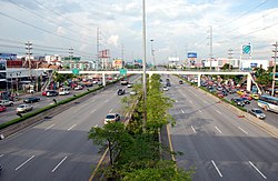
 Rama II road in the area of Bang Khun Thian | |
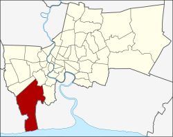
 Khet location in Bangkok | |
| Coordinates: 13°39′39″N 100°26′9″E / 13.66083°N 100.43583°E | |
| Country | Thailand |
| Province | Bangkok |
| Seat | Samae Dam |
| Khwaeng | 2 |
| Area | |
| • Total | 120.687 km2 (46.598 sq mi) |
| Population (2017) | |
| • Total | 182,235[1] |
| • Density | 1,509.98/km2 (3,910.8/sq mi) |
| Time zone | UTC+7 (ICT) |
| Postal code | 10150 |
| Geocode | 1021 |
Bang Khun Thian (Thai: บางขุนเทียน, pronounced [bāːŋ kʰǔn tʰīa̯n]) is one of the 50 districts (khet) of Bangkok, Thailand. Its neighbors, clockwise from the north, are Bang Bon, Chom Thong, and Thung Khru Districts of Bangkok, Phra Samut Chedi district of Samut Prakan province and Mueang Samut Sakhon district of Samut Sakhon province. Bang Khun Thian is Bangkok's southernmost district, and the only one bordering the Bay of Bangkok (upper Gulf of Thailand).
- ^ "Population and House Report for Year 2017". Department of Provincial Administration, Ministry of Internal Affairs. Retrieved 2018-04-01. (Search page)
© MMXXIII Rich X Search. We shall prevail. All rights reserved. Rich X Search